
Note: Click on Solar System Exploration: Galileo Legacy Site (NASA-JPL) to get this image at its highest resolution.
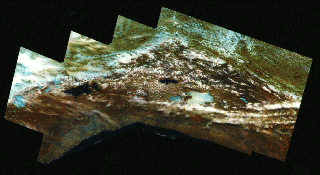
This false-color mosaic of the central part of the Andes mountains of South
America shows the area where Chile, Peru, and Bolivia meet.
The Pacific Coast appears at the bottom of the image.
Galileo captured this view as it traveled west over the Pacific Ocean,
looking back at the Andes.
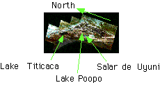
Lakes Titicaca and Poopo are nearly black patches at left and center,
respectively; a large light-blue area below and to the right of Lake Poopo
is Salar de Uyuni, a dry salt lake.
Light-blue patches in the mountains at top and left are glaciers.
Range, 25,000 kilometers (15,500 miles).
Galileo said goodbye, its third and final goodbye to the Earth on December 8, 1992, at 7:09 a.m. PST.
The spacecraft swept within 303.1 kilometers (182 miles) of the South
Atlantic Ocean, its point of closest approach to the Earth.
This, the last of three planetary gravity assists, added 3.7 kilometers per
second (7,992 miles per hour) to the spacecraft's speed in its solar orbit.
In addition, the gravity assist changed the spacecraft's direction slightly,
so its elliptical orbit would intersect the orbit of Jupiter on December 7,
1995, about 780 million kilometers (470 million miles) from the Sun.
The navigation, as in previous gravity assists, was impeccable.
Galileo was within a kilometer of its intended path, and was just 0.1 seconds early.
This false-color mosaic is made up of 42 different images.
The combination of visible and near-infrared filters
(green, 0.76 micron (30 millionths of an inch) and 1.0 micron (40 millionths of an inch))
was chosen for this picture to separate regions with distinct vegetation and soil types.
North is to the left.
For a sense of scale, consider that the dry salt lake Salar de Uyuni is some 120 kilometers (75 miles) across.
These lakes lie in the Altiplano, a region between the western and eastern
Andes, which are covered by clouds.
The water/ice content of the clouds is indicated by their shade of pink
(pinker shades indicates more water content).
The vegetated Gran Chaco plains east of the Andes are pale green (top of picture).
Images like these are a preview of future remote-sensing programs such as the Earth Observing System.
Next slide: The Horn of Africa
Back to: Galileo To Jupiter
Link to: Solar System Exploration: Galileo Legacy Site (NASA - JPL)
Updated: September 23 '96
Best seen with MS Internet Explorer.
Back: ARVAL - Image Gallery
Messages: